Was the "parting of the sea of reeds" was actually in the Hula Lake and the revelation of Mount Sinai was actually in Mount Hermon?
In the last week's torah portion "Beshalach" it is said that the starting point of the Israelites on their journey in the desert was at a place called "Sukkot" (Exodus 13:20). Later they made a detour and camped "in front of the mouth of Hirot between Migdoll and the sea before Baal Tzafon" (ibid 14:2, Tzafon = North). There was the parting of the Red Sea (Yam Suf = sea of reeds), where God put the sea into a "barren place", and they passed through the sea.
The names of these places are supposed to refer us to several other places where places named "Sukkot", "North" and "barren place" are mentioned. First of all, the station where Jacob crossed the Jordan on his way from Haran to the land of Canaan is called Sukkot (Genesis 33:17). This was near his crossing of the Jordan at the Yabok crossing, near a place called Mahanaim (Hebrew for "camps" or "parkings"), and one stop before he reached Shechem. The question is where this place is.
If we follow the book of Joshua, in chapter 13 it is said that all these places were in the possession of the children of Gad. "And their border shall be Jazer, and all the cities of Gilead, and half the land of the children of Ammon, as far as Aroer, which is on the entry for their main city (i.e Amman), and from Heshbon to Ramath Mizpah and Betonim, andfrom Mahanaim to the border of Devir, and in the valley of house of the Highlands, and Beit Nimra, and Sukkot, and the north rest of the the kingdom of Sihon, king of Heshbon of the Jordan, and the border to the end of the Sea of Galilee beyond the Jordan eastward"
It may be possible to understand where this place is exactly, east of the Jordan, but the exact identification is very confusing because it is not clear where exactly the Bashan is located, which was the border between the half-Mansheh allotment and the Gad allotment – with is identified in verse 3 to be the border between the two tribes settlments.
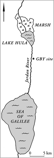
Since according to cross-referenced information from the book of 1 Chronicles, chapter 5, it can be understood that the children of Gad lived right up to the slopes of Hermon, a place where there was a temple to Baal, called in one place "Baal Gad" and in another place "Baal Hermon", it is impossible to know clearly where all the places are these. You can point to two possible places: the present day's Jiftlik area on the "road of the sunrise" from the back of the mountain in the direction of Nablus, or alternatively the "Bridge of the Daughters of Jacob" i.e Jisr Benat Ya'kub (see map: GBY), on the road going up to Hazor or Safed.
The Bridge is indeed identified in Crusader and Arab traditions as the place where Jacob crossed the Yabok river. The place is called "Vadum Jacob" and is probably based on ancient Galilean traditions. We see from Elhanan Rayner's research that the entire Galilee was considered at the time to be "historical" places where the ancestors walked, and the local people tried to locate all kinds of places listed in the Bible at sites in the area. Reiner claims that the Galilean tradition centers on Yehoshua ben Nun in his war in Hazor. In Joshua 11, the enemies against whom the Israelites fought are listed, and by chance these are the same peoples that are also listed in the book of Judges 3, the peoples who dwelt among the Israelites at "Baal Hermon", and were an obstacle to the Israelites. The war was in a place called "Mei Marom" (hebrew: waters of the heights), and the dramatic scene in which the enemies came out was written as follows: "And they went out and all their camp with them, many as the sand flakes on the seashore, and many horses withcvery large chariots and vehicles, and all these kings were appointed and they came and camped together at the Mei Marom to fight with Israel." .
It should be noted the scene in which Pharaoh's army sieges on the Israelites in order to parallel the vehicles of the army, and the fact that in both cases the buildings are described that are related to the term "camps" ("maahanaim") – "hania" and "mahane": "And the Egyptians pursued them and overtook them camped on the sea, all Pharaoh horses and his horsemen rode and fought on the mpouth of the Hirot just before Baal of the north" (Exodus 14:9)
In addition to this, it should be noted that Yavin King of Hazor and his coalition from the book of Joshua included the "kings from the north", and they fought "under Hermon in the Land of Mitzpah". We can understand from this that either from a topographical point of view they looked out towards a certain valley, Mitzpeh is an observation viewpoint located on the slopes of a mountain, or alternatively that their kingdoms are located in some land called "Ramat Mitzpah", i.e highlands of the north. And now the question is what is "mitzpah", what is "north" actually?
I want to fast-forward a little. Mount Hermon is considered a sacred mountain, like the Olympus. Its name suggests that it was a holy place, "haram". We see in the Book of Enoch, Chapter 6, that Samyaza and the other "watchers" or fallen angels decided to swear an oath together and bind each other to a taboo that its translation in hebrew is a "heram", and then mate with the daughters of men. The place where they called for this taboo, and to which they descended, was the top of Mount Hermon and there it is said "And they called it Mount Hermon because there they swore and had a taboo among themselves". In Ugaritic writings it is said that Baal built his palace in "Merom Zaphon". Although some identify it with Jabal al-Aqra in Syria, a place to which the road passes through a town called Hamath – this place can easily be presented as Mount Hermon. After all, it is said in the book of numbers 34 "And this shall be your northern border from the great sea; you shall set the mountain over the mountain ("hor haar"), from the mountain over the mountain you shall set toward Hamath and move along to the border by its side. And the border continues to move to Zifron until the court of Einan, this will be your northern border".
In Ezekiel 47-48, when the border of the land is specified, it is explicitly stated: "And this is the border of the land to the north end of the Great Sea, the way is Hatlon to come to its side" "Hamath, Berothah, Sibraim, which is between the border of Damascus and the border of Hamath of the Middle Court, which is to the border of Hauran." "And these are the names of the tribes from the corner of the north to the hand the road of Hatlon, towards Hamath, the court of Einan, the border of Damascus, north to hand of Hamath, and they had one Dan's side eastwards". Meaning: the places that are at the corner of the north and are called "Hatlon", "court of Einan", "Hamath", etc. are in the Damascus area, meaning near Hermon to the east. Hamath itself is on the Hauran border, east of the Golan (is it Hamath Gader, Emmatha, al Hamma?).
In the Song of Solomon it is said "My bride with me from the Lebanon, my bride with me, you'll come, you'll come from the top of the Amanah river, from the top of Snir and Hermon, from the home of the lions and from the mountains of tigers". Aramaic general Naaman said to Elisha that there are two rivers in Damascus, Amanah and Parpar. In the Babylonian Talmud, Hor Hahar is identified with mountains of Amnon, and the Yonatan Targum also identifies it with "Toros Amanos". All we have to do is to identify Hor Hahar with the higher peaks of the Anti-Lebanon, the place from which the Amanah (Barada river) flows, perhaps the remains of the Roman temples located at the highest point in Hermon, Qasr Habib or Qasr Antar (it should be noted that the Rambam wrote that in his opinion Hor Hahar is near a place called "Banias" but most often identify this one with the Syrian city near Latakia).
Since we identify the place with the Hermon and with the borders of the Promised Land, we also have to put the emphasis on another place that is nearby and where the covenant was made between God and Abraham and his seed promising him the land (Genesis 15) – a covenant between of the pieces, and Mount of pieces (Betarim, مشهد الطير الإبراهيمي, Mashhad A-Tir al-Ibrahim) which is in the area, on the border of the city of Banias.
In his prophecy, Isaiah (32:15) states that "a mountain will become Carmel and Carmel will be considered a forest." Jeremiah calls the whole of Land of Israel "the land of Carmel". The prophets usually mention Carmel in the context of Transjordan, "Carmel and Bashan and Mount Ephraim and Gilead" etc. So it is true that when we talk about the borders of the Land of Israel, we talk about the "border of Carmel toward the sea" (Joshua 19) but there is also a sea in the Jordan Valley, aka the Sea of Hula. The Hula lake was known for the reeds that grow around it and sometimes literally within it ("Heilat" means a kind of reed plant, and also in Arabic the lake was called "Buhayrat al Hula", بحيرة الحولة because of this). And the reason the reeds are growing within it is because the level of the Hula Lake would change with the seasons, by the nature of a swamp. Since a thicket of reeds grew in it, it was also called in ancient hebrew "a forest". And what we can actually understand from Isaiah's prophecy is that in this area there are 3 types of land: swampy land called "forest", green land called "carmel", and from some point when the climate conditions do not allow this the land becomes desolate and devoid of vegetation, this place is called "mountain", or simply "barren place" (Horava, Horeb). Since this place is "bald", it is sometimes also called "Desert" (hebrew: Land of Zia), and since one of the names of Hermon is "Sion" it is possible to understand what the word means – a desolate place empty of vegetation. Alternatively, a high place, "Sion" from the word "Si".
Since the place was a holy place for Baal, it is understandable what the prophet Elijah was looking for in that place. "Carmel" is a green area, and the temple was in the city of Banias, which is the edge of the green area and from there onwards the area begins to become bald. This place is called in the language of the Bible "Shoulder" ("katef"), and indeed we see many places along the Jordan Valley that are called that, such as "Shoulder of Jericho", "Shoulder of the Jebus" – places intended to mark the periphery of a settlement and of lands suitable for cultivation, which are found in the edge of the Desert .
Immediately after killing the prophets of Baal he found his way to Horeb. He didn't have to go that far, because all he had to do was go up the mountain. The mountain itself is restricted and access to it is allowed only to the people of God, as happens in holy mountains (what is called in the language of the Sages: hidden to the righteous "tzafun latzadikim". Tzafun is from hidden, so literally North as Tzafon is a hidden place, like in Joshua 2, Exodus 2, Psalms 27, Psalms 31. The mountain is called "North" because there is a threshold from which only the gods and holy people are allowed to enter, and everything that is beyond the threshold is hidden)
Since Moses also ascended to Horeb, it can also be said that Mount Sinai itself is Mount Hermon. Indeed, in the book of Psalms 68 it is about "the mountain of God, the mountain of Bashan, the mountain of cheese, the mountain of Bashan… Why did you watch out and raise, you cheese mountains, the mountain wanted God to dwell in, even God will dwell in it forever". Obviously, Mount Bashan, the mountain whose peaks look like cheese (indeed, the name of the mountain in Arabic is "the old mountain", or "snow mountain" after its white peaks), is the mountain that God chose for his name to dwell there. Do you remember that the holy mountain was called Zion? We have no choice but to see the land of Zia, and "Sion", as additional names for that holy mountain.
Panias, or Caesarea Philippi, is where Jesus visited when he asked the people who they thought the Son of Man was. Some also see the place where the transfiguration of Jesus took place as Mount Hermon, not Mount Tabor. The fact that two figures appear in the ceremony of Jesus' transfiguration, Moses and Elijah, indicates that both are somehow related to the place, which strengthens the hypothesis. We see that according to Elhanan Rainer Mount Tabor, which is supposedly the place where the transfiguration took place, in the Galilean tradition was in the Upper Galilee, either in Meron or even in Hermon.
And if we are talking about Tabor, which was the place where another war took place between Yavin, King of Hazor, then it is easy to link the place to this war as well. The place of the water in which Sisera's troops were drowned, who also had an iron chariot, is the same place, the water from Merom or the Sea of Hula, and after all, this war is told about (Judges 4) in exactly the same words as it is told about Pharaoh's troops in the Red Sea, "and the Lord shocked them… and all the vehicle and the whole camp hit by the sword" (cf. Exodus 14:24).
Israel Knohl in his book Hashem attributes another war to the place, with the Egyptians. The warrior king was the pharaoh Merneptah and it existed around 1200 BC. He claims that as a result of this war, the song of Deborah and psalm 68 were written as an epic poem of praise. According to him, the war was a rebellion against the Egyptian tax collectors, who burdened the taxes. And this is the origin of slavery to Egypt, when "Joseph" is the collective name for Jeroboam's tribe. That is, the memory of slavery to Egypt of the tribes of Joseph, is nothing but a memory of slavery without going down to Egypt, but slavery to Egyptian rule only, in the Land of Israel. The tradition about a war in which the Israelites went up "armed", about the "armies of God", "infantry corps" going out etc. – is a war of a local army against an occupying army, which was drowned as part of a ruse by the locals when they took them to an unfamiliar muddy area.
The arguement that seals this post is also related to Knohl. According to him, the proof that Mount Hermon is Mount Sinai is found in the double mention of the name Sinai in Psalms 68, "The land shook and the heavens dripped from the presence of God, this is Sinai, from the presence of God, the God of Israel" as well as "the chariot of God, dozens of thousands of servant angel warriors, my Lord in Sinai in the holy place". The fact that the name Sinai is mentioned twice here is a reference to the union of the pantheons that the Israelites had when they arrived from Haran, and their foundation in the worship of the calf. The calf, or bull, is an animal that, on the one hand, according to Ugarit writings, was considered a symbol of strength and fertility and was attributed to the Baal or El, but on the other hand, it was also an attribute of Sin god the lunar bull god who hanged the moon between its horns. The temple in question at Banias (Hermon), is the temple that Jeroboam built in Dan and in it was a golden calf and this is also the nature of the worship that was associated with Mount Sinai and with Aaron the priest, who is buried in Hor Hahar. Jeroboam, is considered in Israeli myth both as the founder of the cult and as the great redeemer from slavery, and slavery was, according to Knohl, the same "suffering" that King Solomon caused when he built his temple from the cedars of Lebanon and gave a tax in the cities in order to build "workers cities, chariots and horsemen", among other things the Horon (remember Hirot, or Hor hahar…), Baalat and Tadmor/Palmira (so to speak, when they talk about the promised land extending to the great river Euphrates, this is how we see from our analysis first about the essence of the boundaries, and also according to what is written in the books of 1 Chronicles 5, it seems that they are talking about the fact that the sons of Reuben, Gad and half of the Manasseh, They will spread from Hauran eastward to the edge of the desert in the Syrian desert, "And to the east he will dwell until he comes to the desert where the river Euphrates comes from, because their descendants are numerous in the land of Gilead" – i.e. Tadmor)
הצטרפו לרשימת התפוצה שלנו
כתיבת תגובה